


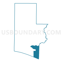
ROSEMA-Voting District, Walton County, Florida
About
Outline

Summary
| Unique Area Identifier | 560161 |
| Name | ROSEMA-Voting District |
| County | Walton County |
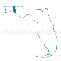
| State | Florida |
| Area (square miles) | 62.78 |
| Land Area (square miles) | 40.03 |
| Water Area (square miles) | 22.74 |
| % of Land Area | 63.77 |
| % of Water Area | 36.23 |
| Latitude of the Internal Point | 30.31563390 |
| Longtitude of the Internal Point | -86.03449890 |
Maps

Graphs
Select a template below for downloading or customizing gragh for ROSEMA-Voting District, Walton County, Florida


Neighbors
Neighoring Voting District (by Name) Neighboring Voting District on the Map
- 11-Voting District, Washington County, FL
- 8-Voting District, Bay County, FL
- 9-Voting District, Bay County, FL
- BRUCE-Voting District, Walton County, FL
- FREEPO-Voting District, Walton County, FL
- POINT-Voting District, Walton County, FL
Top 10 Neighboring County Subdivision (by Population) Neighboring County Subdivision on the Map
- Panama City Beaches CCD, Bay County, FL (35,612)
- Walton Beaches CCD, Walton County, FL (18,452)
- Vernon CCD, Washington County, FL (13,058)
- Southport CCD, Bay County, FL (9,567)
- Freeport CCD, Walton County, FL (9,405)
Top 10 Neighboring Place (by Population) Neighboring Place on the Map
Top 10 Neighboring Unified School District (by Population) Neighboring Unified School District on the Map
- Bay County School District, FL (168,852)
- Walton County School District, FL (55,043)
- Washington County School District, FL (24,896)
Top 10 Neighboring State Legislative District Lower Chamber (by Population) Neighboring State Legislative District Lower Chamber on the Map
Top 10 Neighboring State Legislative District Upper Chamber (by Population) Neighboring State Legislative District Upper Chamber on the Map
Top 10 Neighboring 111th Congressional District (by Population) Neighboring 111th Congressional District on the Map
Top 10 Neighboring Census Tract (by Population) Neighboring Census Tract on the Map
- Census Tract 9506.01, Walton County, FL (8,579)
- Census Tract 9703.02, Washington County, FL (6,615)
- Census Tract 2.02, Bay County, FL (5,329)
- Census Tract 2.01, Bay County, FL (4,238)
- Census Tract 27.01, Bay County, FL (4,073)
- Census Tract 9505.01, Walton County, FL (3,718)
- Census Tract 9506.02, Walton County, FL (2,506)
- Census Tract 9900, Walton County, FL (0)
- Census Tract 9900, Bay County, FL (0)
Top 10 Neighboring 5-Digit ZIP Code Tabulation Area (by Population) Neighboring 5-Digit ZIP Code Tabulation Area on the Map
- 32413, FL (13,128)
- 32459, FL (11,457)
- 32439, FL (7,715)
- 32455, FL (4,736)
- 32462, FL (3,412)
- 32437, FL (679)
- 32461, FL (13)